Amalia Project
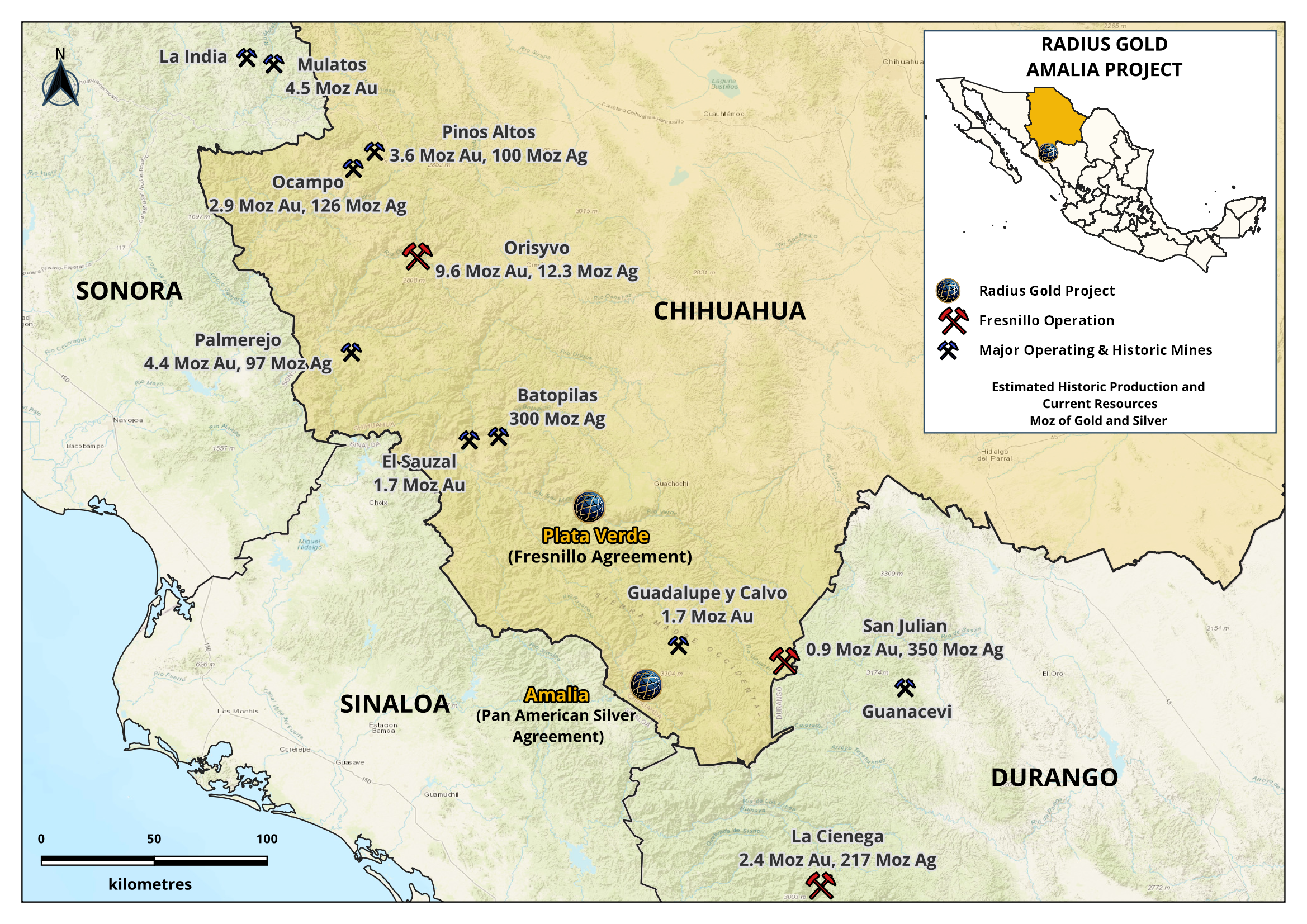
The Amalia Project is located 25 km SW of the historic Guadalupe y Calvo mining district in Chihuahua (Figure 1). Radius geologists discovered high grade epithermal silver-gold mineralization in several veins, vein breccias, and disseminated zones over 8 km of strike length and a 1 km vertical interval following the trace of a large regional fault zone. Radius initially acquired the 380 hectare core license and subsequently staked an additional regional license covering multiple target areas (Figure 2) that totals approximately 10,000 hectares that composes the Amalia project. In July 2018 Radius entered into an agreement with Pan American Silver Corp. to drill and explore the project.
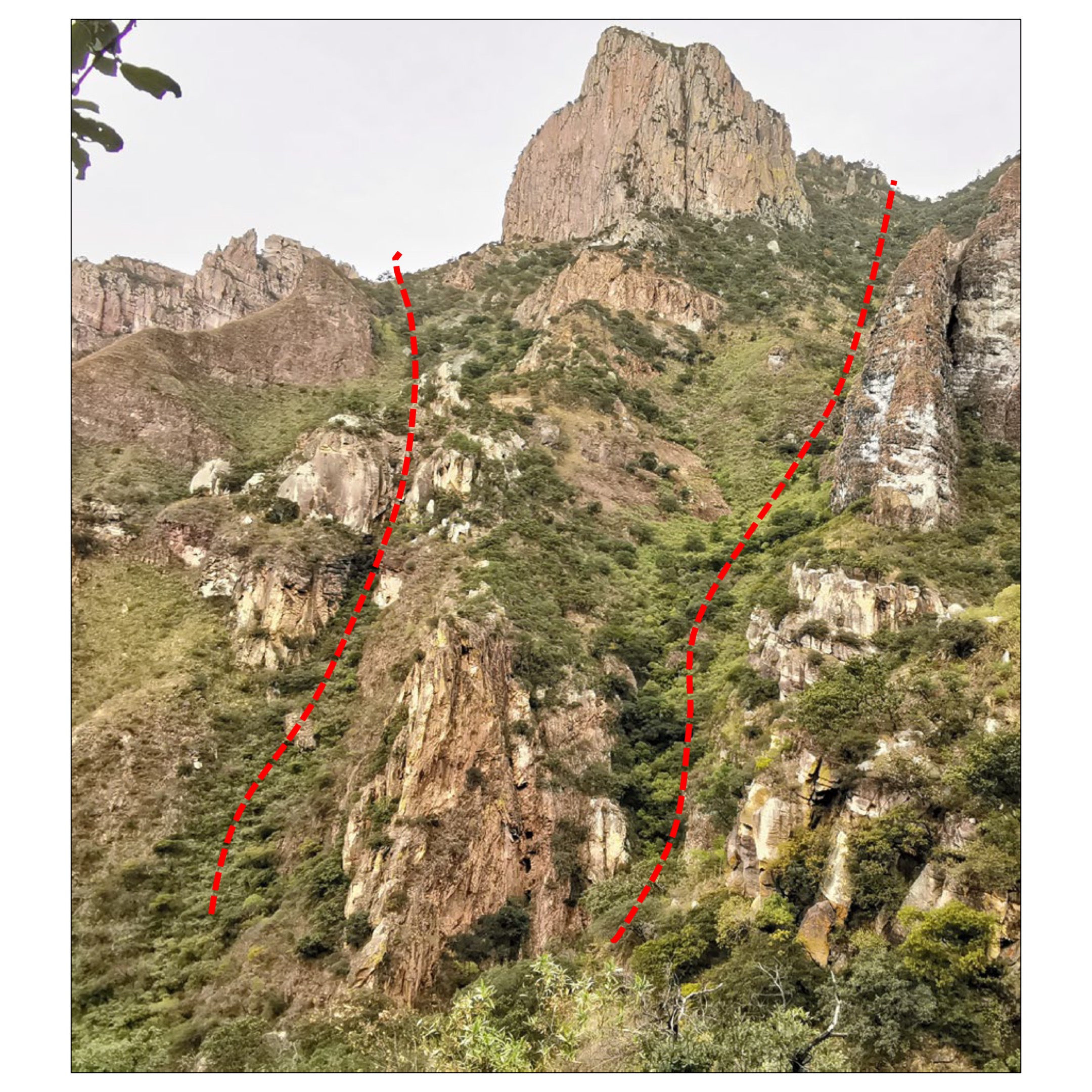
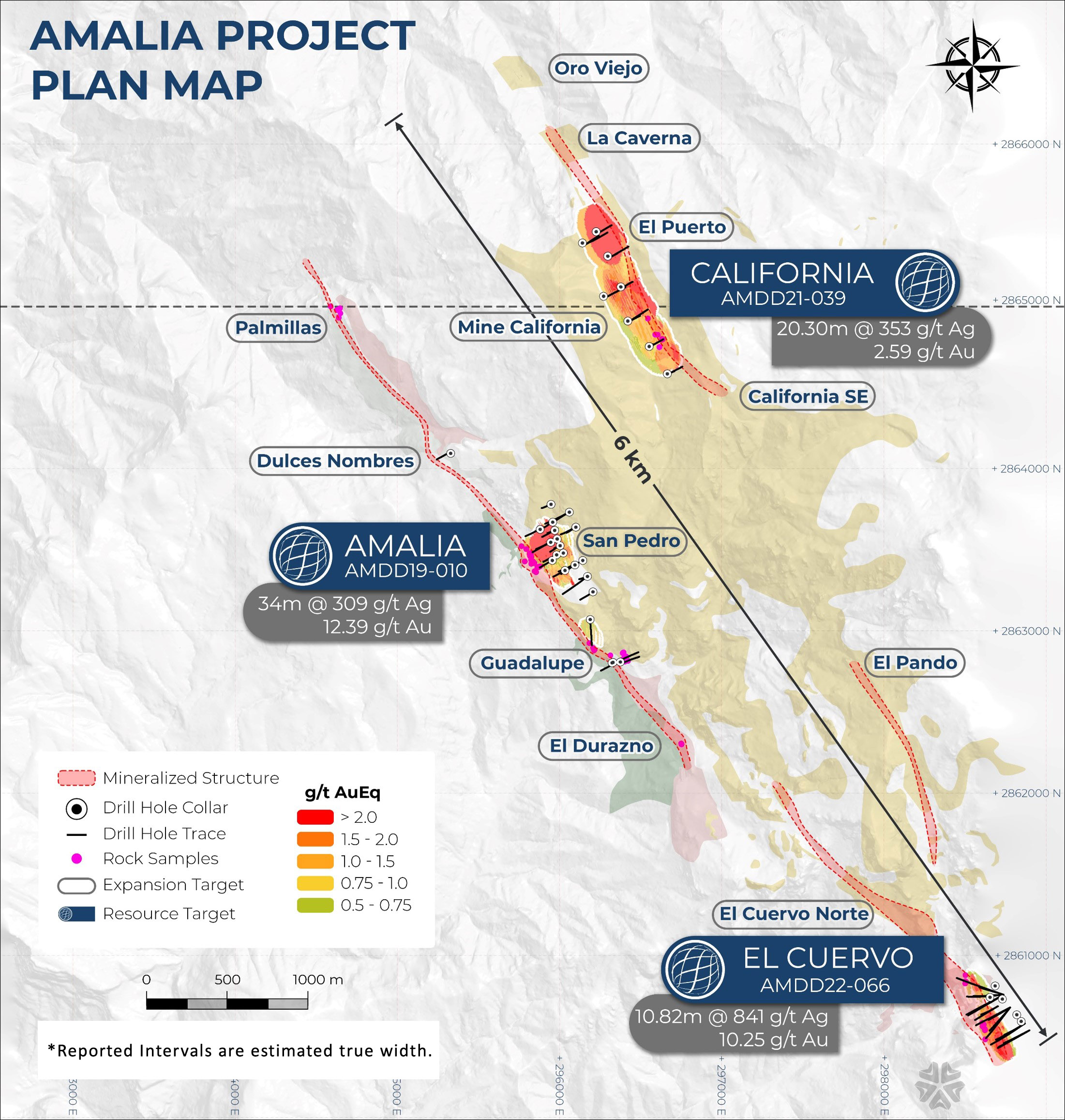
The Amalia project includes the Amalia, California and El Cuervo major vein systems. Within these major vein systems are multiple targets, outlined in Figure 3, all of which are included in Radius's consolidated concessions that extend for more than 10 km of strike length of the regional fault.
To date, there has been over 23,000 m of drilling across the greater Amalia Projects’ three major vein structures: Amalia, California and El Cuervo with impressive wide and high-grade gold and silver intercepted at each of the three main targets drilled to date. Examples of top drill holes from each zone may be viewed in the table below:
Amalia Project Targets – High Grade Intercepts
|
Amalia: 3.9 km vein & breccia |
|
|
California: 3.5 km vein & breccia |
|
|
El Cuervo: 2.7 km vein & breccia |
|
The Agreement
Pursuant to an option agreement signed in June 2018, Pan American Silver Corp. has completed its right to earn an initial 65% interest in the Amalia Project.
![]()
Mining Property
The approximately 10,000 hectare property (Figure 2) includes the Amalia, California and El Cuervo major vein systems. Within these major vein systems are multiple targets, outlined in (Figure 3) all of which are included in Radius's consolidated concessions that extend for more than 10 km of strike length of the regional fault.
The Amalia Project is comprised of 1,681 hectares of granted exploration licences and 8,613 hectares of licence applications. The licence applications have been processed by the state authority in Chihuahua and approved for title.
In May 2023, The Mining Reform, a new federal mining law became effective and makes major changes to Mexico’s Mining Law including proposing to cancel existing exploration licence applications. As have almost all active exploration and mining companies in Mexico, the Company has filed legal challenges to the application of the reforms on all its properties and projects.
Additional information may be viewed at the link The Mining Reform or viewed in Radius Gold’s Interim Management’s Discussion and Analysis – Quarterly Highlights for the Nine Months Ended September 30, 2023 on the Company’s website at www.radiusgold.com and sedarplus.ca
Structures:
- Amalia Vein System: 3.9 km length with a drill defined 250 m long San Pedro high-grade zone. Maximum mineralized true width 74 m (Figure 4)
- California Vein System: 3.5 km length with a drill defined 1000 m long mineralized zone. Maximum mineralized true width 30 m (Figure 5 – California Target)
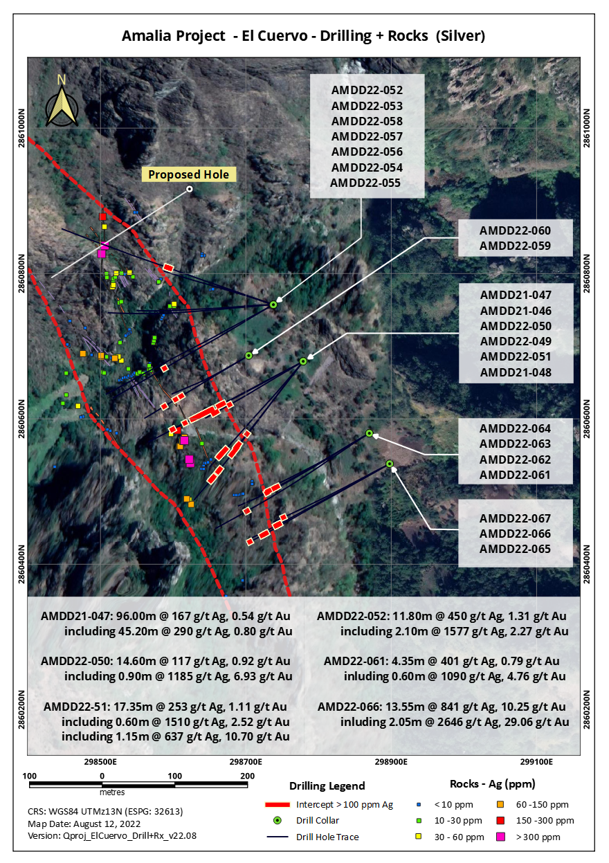
- El Cuervo Vein System: 2.7 km length with a drill defined 440 m long mineralized zone. Maximum mineralized true width 83 m (Figure 6, 7,8).
Amalia Project – Cross Section:
 |
Amalia Strike & Depth Potential
1100 m drill defined depth potential (open). Multiple targets over 12 km of mineralization structures.
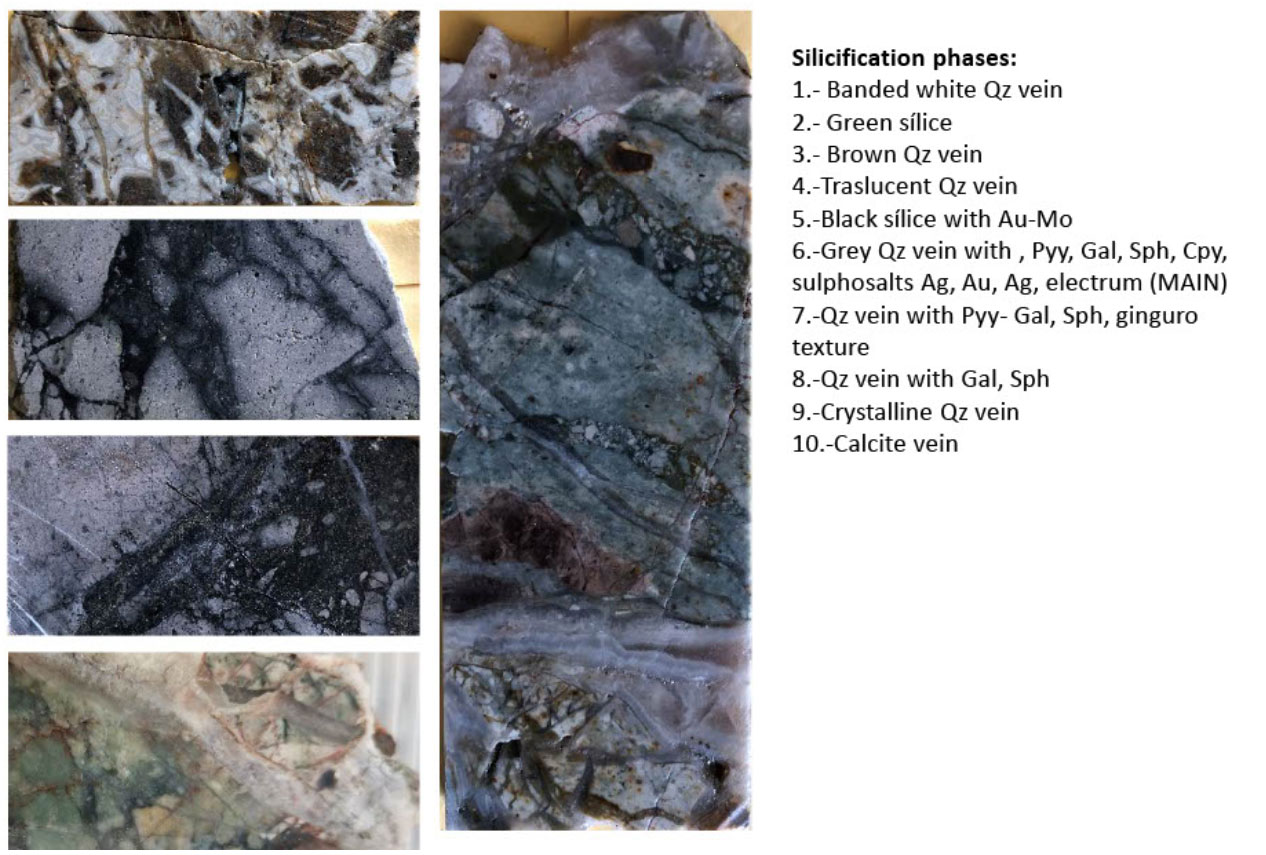
Geology and Mineralization:
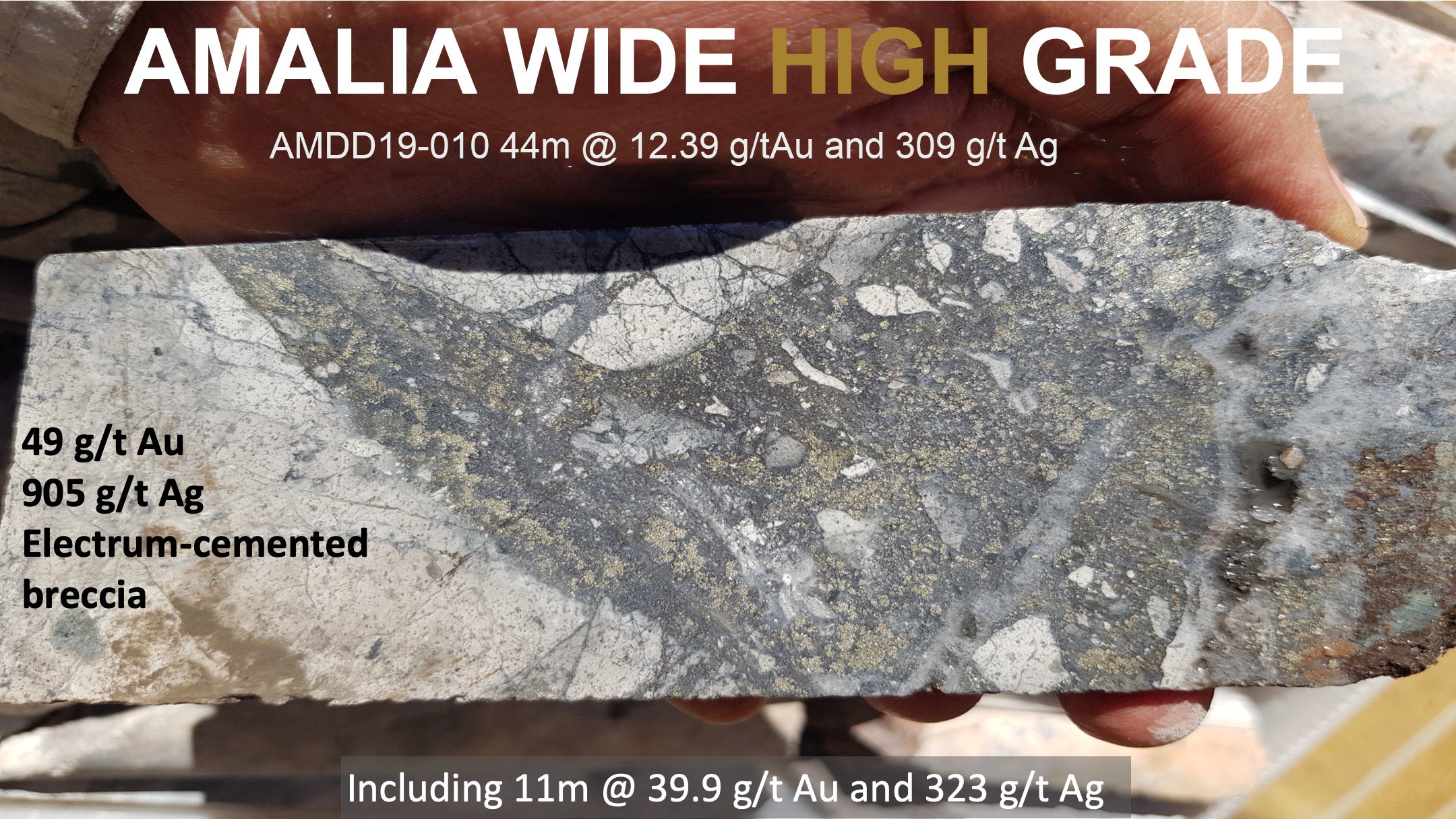
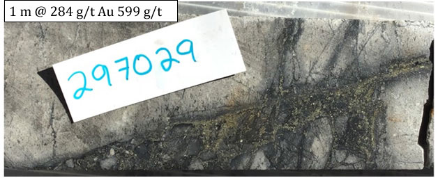
The main targets at Amalia are located along a large regional scale NW trending fault system, which separates the upper rhyolite volcanics from the lower andesite volcanics. Radius has identified outcropping mineralization over 8 km along this structural break. The targets comprise multiple zones of intense epithermal multiphase silicification, and brecciation with stockwork veining occurring at the contact between the upper rhyolite and lower andesite volcanic sequence. Figure 9 showcases multiphase silicification events in drill core from San Pedro. See Figures 10 and Figure 11 for 1 m core samples with electrum mineralization within the quartz sulphide stockwork zone.
Summary of Drilling
Funded by Pan American, a total of 67 drill holes (23,058 m) has been completed at the Amalia Project, across the Amalia, California and El Cuervo projects, and results may be viewed at the Table of Intercepts tab on the menu bar. Drilling at these three targets included:
- Amalia vein system: 31 drill holes (10,588 m)
- California vein system: 14 drill holes (3,814 m)
- El Cuervo vein system: 22 drill holes (8,656 m)
Exploration Targets
Within the approximately 10,000 hectare Amalia Property are multiple prospects which have been prospected and are developing as future drilling targets.
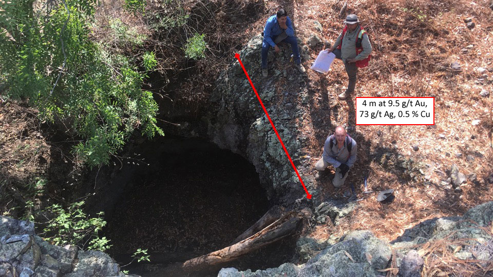
Palmillas target is a small historic working, located 1.5 km along the Amalia Fault from the San Pedro zone. At Palmillas, Radius took a 4 m section that assayed 9.5 g/t Au and 73 g/t Ag, and a 10.5 m section that assayed 1.54 g/t Au and 58 g/t Ag. Mineralization is hosted within fault-controlled quartz vein breccias similar in style to San Pedro (Figure 14). (See News Release: Radius Gold Reports Results from the Third Phase of Drilling at Amalia High-Grade Gold-Silver Discovery, and Acquires the Adjoining 800 ha Palmillas Property, January 14, 2020.)
There are untested vein breccia targets along the California vein system, including the Oro Viejo, La Caverna, California SE, El Durazno, El Pando, with gold grades from below detection to 27 g/t.
Quality Assurance and Quality Control
Pan American Silver has been the operator on Amalia since Q3 of 2019; all their surface samples and drill core have been analyzed at an ISO/IEC accredited ALS Geochemistry laboratory.
Previous rock samples were acquired by Radius Gold's geologists and trained sampling teams under the supervision of the geologists. Majority of the rock samples consist of chip channels ranging from 0.5 m to 3 m. These samples are forwarded to an ALS Geochemistry laboratory for analysis of Au, Ag and other elements using ALS codes Au-ICP21 and ME-ICP61. Au-ICP21 is a fire assay method with an ICP-AES finish for Au. ME-ICP61 is a 34 multi-element (includes Ag) analysis that uses a four acid-digestion with an ICP-AES finish. For over-limits of Au or Ag, analysis using a fire assay method with gravimetric finish is automatically conducted. Quality control samples (blanks, standards etc.) are included with the field samples at regular intervals. The QA samples' results are monitored to ensure the returned results are within the acceptable range.